|
|
|

ATTRACTIVE PARKS OF CANADA 1  | Simo Jelača | |
| |
detail from: KRK Art dizajn
ATTRACTIVE PARKS OF CANADA
Dr sci. SIMO JELAČA
ALGONQUIN PARK
Algonquin National Park is located between Georgian Bay and the Ottawa River, in central Ontario. For camping it is best to stay in the park in the summer months, and to enjoy the autumn colors at the end of September and the middle of October. 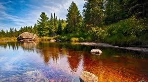 The greatest significance of the Algonquin Park is in its vast expanse. The park abounds with rocky ridges, and thousands of lakes. The only way to explore the vast expanse of this park is to ride a canoe or go by foot. The park comes through road number 60. Here are the special enjoyment of camping in one of the eight camps, walking one of the 14 trails, and participating in extensive programs. Natural heritage is education about the natural resources and the beauty of the park. For the visitors of the Algonquin Park there is an exceptional Art Center for visitors. The Logging Museum, which has been offering "Public Wolf Howl" for more than 75 years, every Thursday in August, is a very attractive program on ecology. In the lakes there is excellent trout fishing, especially in May. There are also possibilities of seeing Moose deer along Highway 60, because they are attracted to the road after winter. In the spring there are also outstanding opportunities for observing birds in the park during spring migrations.  Regardless of how the visitor organizes his stay in the park, it is best to spend the day exploring the Algonquin Park with canoeing, which is the best way to enjoy. This program is a great choice for those who do not have time to stay longer or may not feel fully prepared to spend the night in the forest. It should be borne in mind that you can not go on a trip by canoeing without a life-saving belt, useful advice and suggestions from the instructor. The best way is to come to the "Algonkin" for a long-day canoe trip. Algonquin Park is an area of nearly 8,000 square kilometers of a phenomenal natural desert, over 2,000 kilometers of canoe roads and hundreds of kilometers of hiking trails. Algonquin Park can not be fully seen in just one day. It takes a lot of days, and maybe even a whole year, for a real and complete acquaintance with the park. Outfitters offer canoe rental with all the necessary equipment and canoe trails. There are opportunities for fishing and at the same time teaching children how to do it. Staying in the Algonquin Park is really enjoyable in the wild. It is not enough to say in any vocabulary that could fully describe all the beauty of the Algonquin Park.
CANADIAN PRAIRIE
Canadian prairie is a plain of the plains in the provinces of Alberta, Saskatchewan and Manitoba. The area of prairie usually refers to some kind of lawn. However, "Prairie" can also apply to all plains in the region of Canada, as opposed to Rocky Mountains and the continuation of the Great Plains in the United States.Prairie in western Canada is partly covered by pastures. It also includes parts in the northeast of British Columbia, although this province is not included in the region of prairie in political terms. According to the climatic classification, Canadian prairie generally has a dry climate, with about 300 to 380 mm annual precipitation in semi-arid areas, or 410 to 510 mm in the continental region. Manitoba is mostly the coldest and most powerful of the three provinces of Provinces.Prairie has about 6,000 square kilometers of plains with a center in the Red River valley in Manitoba. The Prairie Plain extends from Canada to the south to Texas. On widespread parts of prairie in southern Saskatchewan and southeastern Alberta many cattle are grazed. The zones around the cities, east of Calgary, are also very dry. In one average year, southern Saskatchewan has about 300-510 mm of precipitation, mostly between April and June. Frost from October to April (and sometimes even in early May) limits the growth season for individual crops. The middle parts of Alberta and Saskatchewan are wetter than the south and have better agricultural land. Areas around Edmonton and Saskatoon are particularly important as well as fertile soil. However, further north, the area becomes too cold for most agricultural crops, except for wild varieties of rice and oats. It is otherwise dominated by forests.

According to the 2011 census, the Canadian Prairie province had a population of 5,886,906, of which 3,645,257 in Alberta, 1,208,268 in Manitoba, and 1,033,381 in Saskatchewan. These three provinces have a total area of 1,780,650.6 km², which consists of 640,081.87 km² in Alberta, 552,329.52 km² in Manitoba, and 588,239.21 km² in Saskatchewan. The primary industry is based on the processing of agricultural crops (wheat, barley, rapeseed, oats), and cattle products (cattle, sheep, pigs and poultry). In addition, natural resources of oil sand (Fort McMurray, Alberta) and other forms of oil production can also be found in the plains. The secondary industry consists of processing oil and other agricultural products.While traveling on the Trans-Canada Highway, no. 1, there are plains with countless farms of more than a thousand hectares of wheat, which gently swing in the breeze, or huge meadows with large livestock. Glacial period left a trail on the prairie, melting glaciers. These deposits are now fertile plains that largely define the Canadian granary. Gas and oil is also abundant in this region.Almost 95% of the prairie area has been converted into agricultural land. Trees and shrubs are most commonly found in the eastern region. From the trees in the prairie are white and black spruce, conifers, birch, willow, pine, jasper, and poplar balsam. In addition to cereals, here are a few other herbs of plants, yellow cactus, barbed pear, alkaline grass, wild barley, oat grass, aspen, grass, and yellow beans. Of the animals, large carnivores in the prairie are black bear. Large herbivores include antelopes, deer and salmon. Small beasts include coyotes, badgers and foxes. Some of the birds of prey are hawks, owls, and hazelnuts. The fish in the Prairie Rivers are pike and carp. Despite the enormous amount of land in agriculture, farmers make up less than 10% of the four million people, and 80% of that population lives in urban areas.In the distant past, millions of buffaloes lived in Prairie. The Indians chased them for their survival, using meat for food and leather for making clothes and footwear. When the white man occupied the territories, the Prairie was almost completely destroyed due to the hunt for skin trade.
BANFF NATIONAL PARK
The tourist dream of many Canadian Rocky Mountains is the Banff National Park, a 90-minute drive west of Calgary. It was founded in 1883, after which thermal mineral waters were discovered, and became the first national park of Canada in 1885. Today, Banff is a world heritage site.

This National Park lies in the heart of the magnificent province of Alberta and is the focal point of Canada, as its most beautiful landscape. Turquoise green lakes, snow peaks, and glaciers are all easily accessible in this stunning park. The jewel of the park is Lake Louise, where green waters reflect the surrounding mountains and visitors can easily walk along its shores. Frozen mountain peaks, stretching from Lake Luis to Jasper are unforgettable. At the south end of the park is a beautiful small town Banff, which offers all types of accommodation, shopping, and dining options.In winter, Banff is also a great winter sports center, a ski resort "Sunny Village", the most prominent Canadian ski destination.Located in the heart of the park Banff and the hamlets in its vicinity have all kinds of services and are right places for adventure. During the summer, camps are set up, from where visitors can explore the paths of 2560 км long, with deer, salmon and bear. Surrounded by high mountain peaks, the magnificent Victoria Glacier and the lush emerald Lake Luis is the Chateau Hotel, which is also the world heritage of UNESCO, and is recognized for the progressive preservation of the environment and responsible tourism. Lake Luis is a Canadian "Diamond in the Desert" and "The Capital of Hiking in Canada". This area offers enormous diversity for recreational opportunities and sightseeing. Lake Luis is the site of one of the best ski resorts in North America. The region abounds in spectacular landscapes, from glaciers to waterfalls. Moraine Lake is a glacial lake at Banff National Park, 14 kilometers ahead of Lake Louise. It is located in the valley of the Ten Peaks, at a height of about 1,885 meters. The lake has an area of 0.5 square kilometers. The lake, as glacial, does not dissolve completely until mid-June. When dissolved, it reflects a special shade of blue. Blue is due to the refraction of light from the snow-covered wall in the Moraine Lake.Among all the natural beauties of Canada, there was also a place where the Canadians gave the name of the famous Serbian military commander from the First World War, Vojvoda Radomir Putnik. From respect to the hero who, with great losses in extraordinary command, managed to defeat the supreme force of the Austro-Hungarian monarchy and thereby put the Serbian name on the pages of world history. This mountain of Vojvoda Radomir Putnik is located north of Three Isle Creek and west of Kananaskis River. The Putnik Mountain is located not far from the city of Calgary.
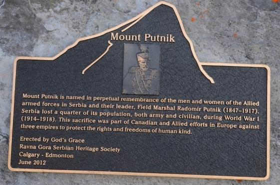
The Canadians named the "Traveler" in the vicinity of the province of Alberta, commemorating the Chief of the Supreme Command of the Serbian Army (1912-1916) and the first Serbian duchess Radomir Putnik (1847-1917). This mountain is part of the Rocky Mountain Range between the Canadian provinces of Alberta and British Columbia in the Kananaskis Mountain Range and is 2,940 meters high. The words "The Patnik Mountain" are named in the sign of eternal memory of men and women from allied armed forces in Serbia and their leader, the dukes of Radomir Putnik (1847-1917). Serbia lost a quarter of its population, both members of the army and civilians during the First World War (1914-1918). This victim was part of Canadian and allied fights in Europe against three empires in order to protect human rights and human freedom".
|